A Statewide Partnership.
The Texas Clean Rivers Program (CRP) is a partnership between the Texas Commission on Environmental Quality (TCEQ) and regional water and river authorities across the State. Partners conduct water quality monitoring, assessment, and stakeholder participation to improve the quality of surface water within 25 river basins in Texas.
Routine monitoring and water quality testing in rivers, lakes, bays and the Gulf of Mexico determine if established standards are being met. If standards are not being met, then a variety of actions can be prescribed to further evaluate and address the identified problem.
Our Area of Responsibility
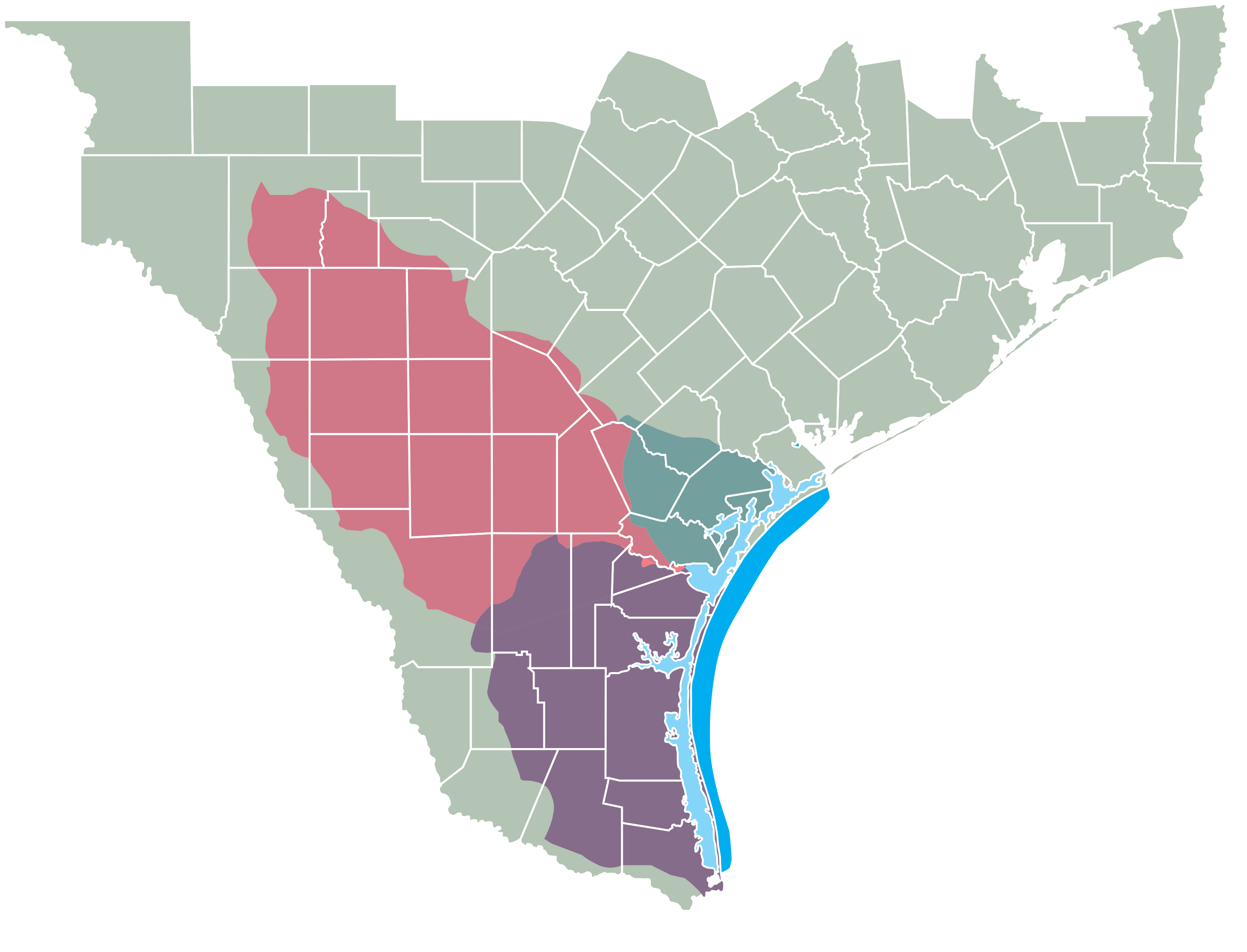
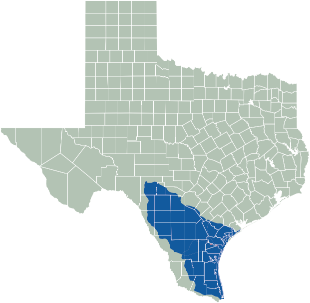
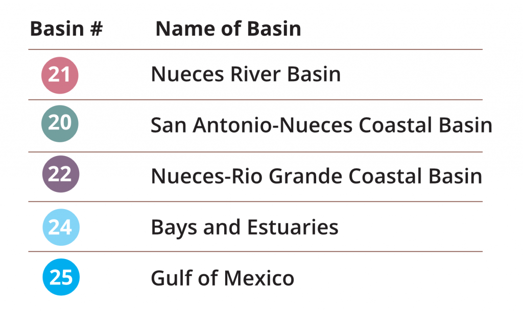
The Nueces River Authority (NRA) implements the Clean Rivers Program in the Nueces River basin and associated coastal basins as well as several bays, estuaries, and a portion of the Gulf of Mexico. Each of these are shown by Basin Number below and color-coded map.
The NRA Area of Responsibility covers 30,500 square miles, parts of five basins, and more than 100 waterbodies and assessment units. NRA coordinates with four TCEQ regions: 13 (San Antonio), 14 (Corpus Christi), 15 (Harlingen), and 16 (Laredo) to keep data updated according to a set schedule.
For a comprehensive and downloadable list of waterbodies and assessment units within the NRA’s Area of Responsibility, CLICK HERE. Segment number (Seg ID) and the Assessment number (AU ID) may be useful when searching for monitoring data within either TCEQ’s or NRA’s data viewers.
Water Quality Monitoring
What is Monitored and Why
for aquatic life

- Chloride
- Sulfate
- Total Dissolved Solids (TDS)
for public water supply

for contact recreation

- Water temperature
- pH
- Ammonia
- Nitrogen
- Phosphorus
for general use

for fish consumption

Monitored Water Bodies
Currently, more than sixty water bodies are being monitored within the NRA’s Clean Rivers Program Area of Responsibility. Each water body has a unique number that begins with the basin number where the water body is located. Some water bodies have more than one regular monitoring site.
Below is a scrolling list of water bodies currently monitored by NRA. Download the full Excel file HERE.
The Importance of Water Quality Standards
The table below explains the potential impacts when water quality standards are not met and provides the most common causes for concerns and impairments.
| Parameter of Concern or Impairment | Impact | Cause |
|---|---|---|
| Dissolved oxygen (DO) | Organisms that live in water need oxygen to live. In waters with depressed DO levels, organism may not have sufficient oxygen to survive. | Modifications to the riparian zone, human activity that causes water temperatures to increase, and increases organic matter, bacteria and over-abundant algae. |
| pH | Most aquatic life is adapted to live within a narrow pH range. Different organisms can live and adjust to differing pH ranges, but all fish die if pH is below 4 (the acidity of orange juice) or above 12 (the pH of ammonia). | Industrial and wastewater discharge, runoff from quarry operations, and accidental spills. |
| Ammonia | Elevated levels of ammonia in the environment can adversely affect fish and invertebrate reproductive capacity and reduced growth of the young. | Ammonia is excreted by animals and is produced during the decomposition of plants and animals. It is an ingredient in many fertilizers and is also present in sewage, stormwater runoff, certain industrial wastewaters, and runoff from animal feedlots. |
| Nutrients Nitrates Total phosphorus |
These nutrients increase plant and algae growth which can impact recreation uses. Some waterbodies naturally carry almost no nutrients and are especially vulnerable to changes in nutrient levels. When plants and algae die, the bacteria that decompose them use oxygen so that is no longer available for fish and other living aquatic life. | Nutrients are found in effluent released from wastewater treatment plants, fertilizers and agricultural runoff carrying animal waste from farms and ranches. Soil erosion and runoff from farms, lawns and gardens can add nutrients to the water. |
| Chlorophyll-a | Chlorophyll-a is the photosynthetic pigment found in all green plants, algae and cyanobacteria. Elevated levels indicate abundant plant growth which could lead to reduced DO levels. | Modifications to the riparian zone, human activity that causes water increases in organic matter, nutrients, bacteria and over-abundant algae. |
| Total Suspended Solids (TSS) | TSS are particles that are suspended in water. Elevated TSS levels affect light penetration. Deposition of these particles can also bury and/or destroy benthic habitat for most species of aquatic insects, snails and crustaceans. | TSS originates from multiple point and nonpoint sources, but most commonly results from erosion of soils substrates. A good measure of the upstream land stewardship and associated riparian conditions is how much TSS rises after a heavy rainfall. |
| Total Dissolved Solids (TDS) Chloride Sulfate |
High levels of these parameters may affect the aesthetic and useful quality of water, altering aquatic communities and interfering with domestic uses like clothes washing, cooking and ice making, while corroding plumbing fixtures. | Mineral springs, carbonate deposits, salt deposits, and sea water intrusion are natural sources of these parameters. Other sources can be attributed to oil exploration, drinking water treatment chemicals, stormwater and agricultural runoff, and wastewater discharges. |
To learn more about the water quality assessment standards, screening criteria and triggers for concern and impairment, please see the most recent NRA Basin Report’s early chapters on Water Quality Monitoring, Conditions and Terminology.
Monitoring for the Federal Clean Water Act
![]() Sections 303(d) and 305(b) of the federal Clean Water Act require assessment of official water quality monitoring data for the purpose of identifying water bodies in or bordering Texas for where standards are not being met.
Sections 303(d) and 305(b) of the federal Clean Water Act require assessment of official water quality monitoring data for the purpose of identifying water bodies in or bordering Texas for where standards are not being met.
The 303(d) list contains water bodies that are impaired or do not meet the standards for their designated uses. The 305(b) list contains those segments that are determined at risk of impairment.
Texas 303(d) and 305(b) Lists Texas Surface Water Quality Standards
Wastewater Permits
 The discharge of waste and pollutants into surface waters is expressly prohibited, except as allowed by permit. The TCEQ issues permits for discharge of wastewater and pollutants into surface waters within the State.
A complete list of wastewater discharge permits within the NRA’s Area of Responsibility can be found HERE.
For complete list of wastewater discharge permits in Texas, use the TCEQ NPS Viewer below.

Water Quality Data Viewers
Official water quality data for Texas is stored in a database called the Surface Water Quality Monitoring Information System (SWQMIS). This data is collected under specifically prescribed protocols designed for quality assurance. Often, official water quality data can be difficult to locate and not easily understood.
On this website, we offer access to all official water quality data for the Nueces, Nueces Rio Grande and Nueces San Antonio basins as well as the bays, estuaries in the Gulf of Mexico and Laguna Madre within our Area of Responsibility.
CRP Basin Reports
NRA compiles a complete Basin Summary Report (BSR) and Basin Highlights Report (BHR) containing the data collected on all
waterbodies within the NRA’s Area of Responsibility during reporting periods specified by TCEQ.
These reports identify water quality trends and provide detailed information from all monitoring sites and for specific water
quality parameters. The most recent reports can be found at links below. A complete list of Reports and Studies can be found
on this site.
2021 BHR Report | 2018 BSR Report | 2018 BSR Executive Summary